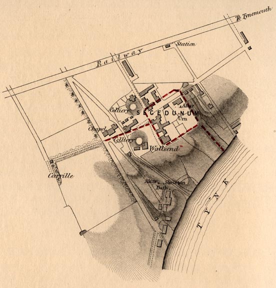
Station at Wallsend [Map of Secedunum]
Lithograph
Kell Bros., Castle Street, Holborn.
Page 10 15/16 x 8 1/16 inches; this section approximately 5 inches sq.
Source: facing Bruce, p. 89
Rockefeller Library, Brown University
[Compare modern photograph — GPL].
Scanned image and text by George P. Landow
[This image may be used without prior permission for any scholarly or educational purpose.]
Bruce's description of the Roman encampment or "station"
The station at Wallsend occupies a site well adapted to military purposes. It stands on a bend of the river, formed by two of its longest "reaches," and, consequently, commands a view of the stream for a great distance in both directions. Without being so much elevated as to give it a painful exposure to the blasts of the north and of the east, it rises above the general level, so as to prevent the possibility of a sudden surprise. The ground in front of it slopes rapidly down to the river's brink, and has a full exposure to the mid-day sun. A defile on its western side added to its security.
When Horsley wrote, the ruins of the station were clearly discernible. Its ramparts could be traced out, and though the interior had been ploughed and levelled, " here were very evident remains of two turrets at the western and eastern entries to the station, and of another at the south-west corner." He found manifest traces of suburban buildings on the slope, between the south rampart of the station and the river, and also "to the south-west of the fort." The station was square, and contained an area of above three acres and a half. The Wall came up to the north cheek of the western gateway, consequently the station projected considerably to the north of the Wall. . . The great Wall was continued from the south-east angle of the station, and brought down into the bed of the river, where it terminated. By this means an attacking force was prevented from getting within the line of the great barrier.
The present aspect of the station is not encouraging. The workings of the colliery, which still gives name to the best class of coal sold for domestic purposes, were commenced in 1770, and continued to the year 1853. The principal shaft was sunk a few yards to the west of the western rampart of the station, and the pumping engine was planted a little beyond its north rampart. The defile on the west was filled up to give a proper level to the "waggon-ways." The stones of the station, some of them with inscriptions, were used in the erection of the colliery buildings, in such circumstances it is not remarkable that the vestiges of the station should be almost entirely removed. [pp. 88-89]
Sources
Bruce, John Collingwood. The Roman Wall: A Description of the Mural Barrier of the North of England. 3rd ed. London: Longmans, Green, Reader, and Dyer, 1867.
Victorian
Web
Social
History
Places
Northumbria
Last modified 8 August 2006