
The following excerpt comes from Chapter XII of Edgar Sanderson's The British Empire in the nineteenth century, its progress and expansion at home and abroad... (see full details in the bibliography). The earlier history of the land having been recorded in the previous chapter, there is no mention here of the Maori inhabitants and their culture. Sanderson had evinced some sympathy for both, particularly applauding the Earl of Onslow, Governor of New Zealand from 1889-1892, for his gestures in this respect. But the focus now is on how New Zealand was flourishing under British rule at the end of the Victorian period. There is an obvious pride in its progress in all areas, from agriculture, industry and shipping to architecture, education and and municipal facilities.
The excerpt has been adapted for the Victorian Web, with the addition of headings, extra paragraphing, and illustrations with captions. Page numbers are given in square brackets. [Click on all the images to enlarge them.] — Jacqueline Banerjee
Christchurch

hristchurch, capital of the provincial district of Canterbury, with a population of about 17,000, or, including the suburbs, nearly 52,000, lies in a plain near the east coast of South Island, on Pegasus Bay. The city has a thoroughly English look in its surroundings of country lanes with hedgerows, neat cottages in garden-plots, and cultivated farms, and in its interior marked by many old-country churches and schools. Belted with trees in all its limits, the place, above a mile square in area, has nearly all its streets laid out at right angles to, or parallel with, each other, the buildings being arranged in rectilinear blocks of equal area and uniform design. The only break in this regularity of plan occurs at the large open space in the centre called Cathedral Square, diagonally crossed by High Street. The shallow pellucid river Avon meanders smoothly through the city between low banks fringed with weeping willows and united here and there by picturesque bridges.
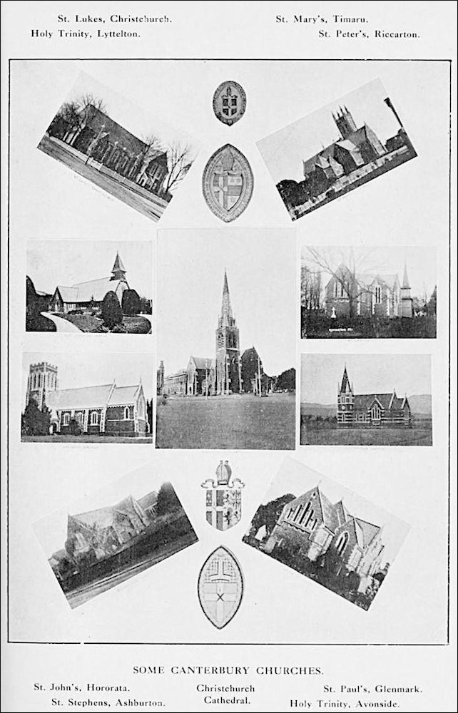
Christ Church Anglican Cathedral, designed by George Gilbert Scott, surrounded by the churches in its diocese. Click on this illustration for more information about the cathedral.
Christchurch, which, as we saw above, was started as a settlement of the Anglican Church, retains some traces of exclusiveness in its social tone, but has in great part succumbed to the power of colonial democratic feeling. The origin of the city is indicated by the names of streets derived from various home and colonial sees — Hereford and Durham, Gloucester and St. Alban's, Tuam and Armagh, Montreal and Madras, and many more. These broad, well-paved thoroughfares, planted with trees, have steam-trams to convey the traveller to his destination when he arrives at the handsomest railway-station in New Zealand. The Cathedral, with a tower 210 feet high, is the finest ecclesiastical structure in the colony, copied from that of Caen, in Normandy. The scholastic edifices are numerous, good, and well-endowed, including Canterbury College, the Anglican Christ's College, High Schools for boys and girls, and a School of Arts; 13 miles away to the south, at Lincoln, we find an Agricultural College, with a farm of 600 acres, and a large staff of lecturers. The Museum has an excellent technological department illustrating [292/293] metallurgy, pottery, and many other industries. Public recreation is provided for in the Botanic Gardens; the Government Domain of 80 acres, almost surrounded by the Avon; and Hagley Park, a reserve of 400 acres, encircled by English trees and Californian pines, and having 10 miles' length of shady walks, and a good cricket-ground. The amusements of the citizens include angling in the river for splendid trout. Cricket and football are specially cared for in Leicester Park, an area of 11 acres. The Canterbury Jockey Club has a fine race-course at Riccarton, 10 miles distant by rail. Christchurch is at its gayest during the summer "Carnival Week" in November, when three days are devoted to the "turf," and two to the yearly show of the Agricultural and Pastoral Association. There are several theatres and public halls. The industrial establishments of this flourishing town comprise flour-mills, breweries, foundries, tanneries, factories for tillage-implements, boots, carpets, carriages, brass and copper ware, pottery, biscuits, pickles, sauces, and fruit-preserves.
Kaiapoi
At Kaiapoi, 14 miles away, are glass-works, and a woollen-cloth factory employing about 500 people, and producing tweeds, blankets, rugs, shawls, and hosiery of the highest quality, specimens of which won a gold medal at the Sydney Centennial Exhibition of 1888. One of the engineering establishments in Christchurch turned out the first ten locomotives constructed in the colony. The place takes the lead in New Zealand in all trade connected with grain and wool, and it was here that the famous New Zealand Shipping Company had its rise. Sumner and New Brighton are popular and pleasant sea-side resorts.
Lyttelton
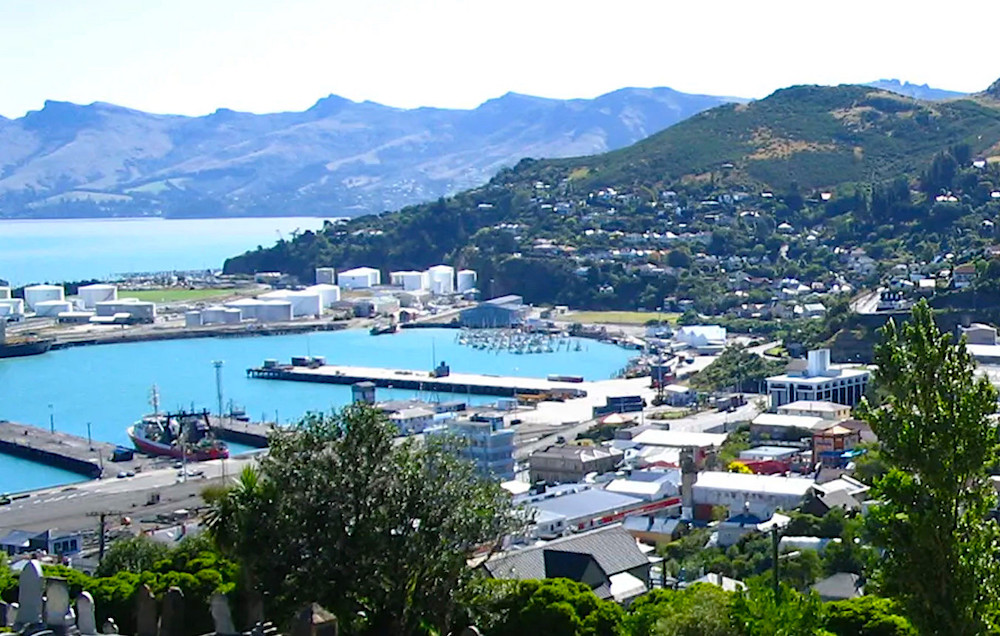
Lyttelton, South Island, New Zealand, cropped from the image in the Encyclopædia Britannica website, under the terms of the GNU Free Documentation License.
Lyttelton, the port of Christchurch, and the outlet for the wheat and wool of the rich Canterbury Plains, is 8 miles distant by railway, one of costly and difficult construction owing to the necessity of tunnelling through a mile and a half of volcanic rock. The town, with a population of 5000, lies on the north-west side of Banks Peninsula, on a contracted area of fairly-level land below a horse-shoe range of bleak, sombre, lofty hills descending on each side with a steep slope to the water's edge. There is abundance of wharfage and storing-sheds on the sea-front, with railway-lines running alongside the ships. The harbour of 107 acres, having water from 19 to 25 feet deep at low tide, is well protected by two breakwaters, measuring in all 3400 feet in length, and constructed at a cost exceeding half a million sterling. A fine graving-dock, [293/295] a patent slip, and electric-lighting on the wharves, complete the accommodation provided for commerce.
Timaru
Timaru, on the coast about 70 miles south-west of Banks Peninsula, is of some importance as the outlet of a large and fertile district, and the second town of Canterbury province, with about 4000 people. The place is solidly built of dark-blue stone quarried near at hand, and has a port formed by a massive breakwater costing about £200,000, and extending for over 2000 feet. There are the usual public and commercial buildings, with factories for various articles, including woollen goods, agricultural implements, and barbed wire for fencing.
Omaru
Oamaru, on the coast about 50 miles further south, has about 7000 inhabitants, and is splendidly built of a fine white limestone abounding in the vicinity, and of quality so good as to be exported to other parts of New Zealand, and even to the Australian colonies.
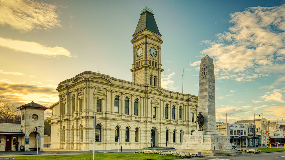
"Oamaru Sunset" by Geoff Challies, taken on 16 September 2022 and kindly made available on Flickr under the terms of the Attribution 4.0 International CC BY 4.0 Deed. This is the old Chief Post Office building, designed by Glasgow-born Thomas Forrester (1838-1907), and opened in 1884. The clocktower was added in 1903. It is now used by the Waitaki District Council. Here, Oamaru limestone is shown off to its full advantage.
The place has a large trade in agricultural produce. Originally having a dangerous open roadstead, Oamaru has now been provided, by skill and enterprise such as those displayed at Timaru, with a safe and convenient port formed by a breakwater and a mole with a total length of 3600 feet, inclosing a water-space of 60 acres. Vessels drawing 24 feet of water can be berthed alongside the wharves, to which a railway brings the trucks. This busy, flourishing, and progressive town has some stately structures, among which we may name St. Columba's Presbyterian Church; all the usual adjuncts of urban life exist, and there are works for woollen and meat-freezing.
Dunedin
Dunedin, the second place in New Zealand for size and population, with about 23,000 inhabitants in the town, or over 47,000 with the suburbs, is the chief city of South Island, and capital of Otago provincial district. It is situated at the head, or south-western end, of Otago Harbour, an inlet 15 miles in depth on the south-east coast. We have seen that it was founded in 1848 by an association of members of the Free Church of Scotland. These enterprising settlers intended to call the place "New Edinburgh," but a happy suggestion of Dr. William Chambers changed this designation for the old Celtic name of the capital of Scotland. A great impetus to its progress was given in 1861, when the discovery of extensive gold-fields in the neighbourhood brought a great influx of miners, notably from Victoria.
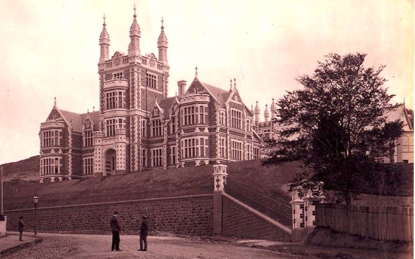
The Otago Boys' High School, Dunedin, designed by Robert Lawson (1833-1902), and built 1882-84.
Dunedin is, in architecture, the finest place in New Zealand. The front displays [294/295] long lines of noble thoroughfares stretching over land that has been won from the sea; the rest of the town is built in tiers of terraces rising upwards over steep heights. The Scottish origin of the city is brought to the remembrance of visitors by the stately First Presbyterian Church, built of the white Oamaru stone. This charming town, bearing some physical resemblance to Edinburgh in its situation on hilly ground by an arm of the sea, is still more like that famous capital in the high esteem in which culture and learning are held. One of the finest edifices is the Boys' High School, and both primary and higher education have been provided for with a lavish hand. The Museum is rich in natural history specimens, and is crowded on Sunday afternoons with visitors of all sorts and conditions. The Botanical and Acclimatization Gardens are beautifully laid out in flower-beds, lawns, shady walks, and ponds adorned by snow-white swans. The Domain is largely composed of primitive bush, affording rough hilly walking for athletic persons. The Knox Presbyterian Church, with a lofty tower and spire, is another fine ecclesiastical building.
Many other imposing structures are devoted to purposes of every kind connected with business, education, philanthropy, and pleasure. The Dunedin Jockey Club, at the Forbury Course, provides for the horse-racing which is a passion with New Zealanders. The Ocean Beach is a grand promenade. The Town Belt, a broad zone of timber along the slopes of the hills above the city, is a beautiful "reserve" of 560 acres, dividing Dunedin proper from the suburban towns on the crest of the heights. The well-paved streets are lit with gas, and ample methods of communication exist in omnibuses, cabs, and horse and cable tramways. The industries of the city and neighbourhood in metal goods are important, and great smoke-stacks show the existence of works for paper-making, fruit and meat preserving, brewing, tanning, and numerous other manufactures. The expenditure of about £700,000 in dredging and other harbour-improvements now enables ships drawing 18 feet of water to reach the wharves, and the new Victoria Channel from Port Chalmers has 22 feet. The commercial rank of Dunedin, which is the head-quarters of the Union Steamship Company, is among the foremost in the colony.
Port Chalmers
Port Chalmers, the outer port of Dunedin, is a substantial little town, 9 miles nearer the sea, on the northern shore of Otago Harbour. A deep narrow [295/296] channel leads up to the wharves from the sea-entrance at Taiaroa Head, a bold promontory with a fixed dioptric light visible for 20 miles. The place is solidly built of bluish stone quarried in the vicinity, and has an excellent graving-dock and a floating-dock, with wharfage for many large vessels. The number of inhabitants is about 3000.
Invercargill
Invercargill, the most southerly town in Australasia, having about 10,000 people in itself and suburbs, stands on an estuary 140 miles, by railway, south-west of Dunedin, at about the centre of the southern coast of South Island. The place is laid out on a very large scale, with the widest streets in the colony, planted with trees, and containing many handsome stone buildings, suitable for what was intended, as it seems, to be the capital of New Zealand. The town and neighbourhood are very busy, having many saw-mills, with breweries, steam flour-mills, foundries, boot and shoe factories, and other scenes of industry. Large meat-freezing works are found at the mouth of the estuary, New River Harbour.
Wakatipu
We conclude with a brief account of a little inland place — Queenstown, situated on the bend of beautiful Lake Wakatipu, half-way between Kingston, at the southern end, and the head of the lake. This picturesque town of about 1000 people, surrounded at the back and on the sides by sombre lofty mountains, is a good centre for excursions to Mount Bowen, Ben Lomond, and other peaks, and to lakes, gorges, and cascades among the high ground of this romantic region.
Bibliography
Greenaway, Richard L.N. Biography: Forrester, Thomas. Dictionary of New Zealand Biography. Web. 14 October 2025.
Mane-Wheoki, Jonathan. Biography: Lawson, Robert Arthur (1833-1902). Dictionary of New Zealand Biography. Web. 14 October 2025.
Sanderson, Edgar. The British Empire in the nineteenth century, its progress and expansion at home and abroad; comprising a description and history of the British colonies and dependencies. London: Blackie, 1898. Internet Archive, from a copy in Robarts Library, University of Toronto. Web. 14 October 2025.
Created 14 October 2025