
In transcribing the following passage from the Internet Archive online version I have expanded abbreviations and added paragraphing, links, and illustrations. — George P. Landow
Capt. Collins, writing in the time of William III., says that ships, coming to Liverpool, put out part of their cargo at Hoylake, to render them light enough to sail over the flats into the Mersey; that the channel up to Liverpool was near Formby, had three fathoms on the bar at low-water, and was not buoyed or beaconed; that ships, on arriving at Liverpool, were left a-ground at low-water, and rode badly afloat iu the flood of tide, on account of the strength of the tidal currents; and that they went up to the Slyne, where there was less strength of current, in order that they might ride better there.
But, since Collins' time, the passage near Formby has been buoyed; a much better passage, which was not known in his days, and which enables ships three times larger than any of those in his period to enter the harbour without discharging any portion of their cargo, has been discovered; a series of brilliant lights, some afloat, others on hills and headlands, and all combining to render the approach and entrance of the Mersey as safe by night as by day, has been set up; a prodigious amount of improvement in the anchoring grounds of the harbour, rendering them good and facile at all states of the tide, has been effected; and a magnificent range of docks, easy of entrance, and giving ships as safe and smooth a berthage as the best natural land-locked harbour in the world, has been formed.

The Liverpool Pilot-Boat No. 8 Leading Twelve Vessels into the Mersey During the Last Gale. Source: Illustrated London News 42 (27 May 1863): 601.
Mersey Docks and Harbour Board
The docks and the ground connected with them form an estate, long under the management of a committee, and in the trusteeship of the town council. The committee consisted of thirteen members elected from the town council, and eight elected from the merchants and ship-owners; and its proceedings were subject to the review of the town council. But since 1857 the dock estate has been managed by a Board, elected by the rate-payers, and called the Mersey Docks and Harbour Board, Two harbour-masters superintend the shipping in the docks; a dock-master attends to the vessels in each dock, allots them berths, and assigns or orders requisite changes of place; and dock-gatemen and policemen perform the minor duties, for regidation of the docks, and for protection of property. The income of the Board, during the year ending in June, 1S66, was £7, 296 on capital account, and £340,050 on revenue account; the expenditure £l,192,62 on capital account, and £32,817 on revenue account; the amount of new loans contracted £1,760,395; the amount of old loans paid off, £87,305; and the amount of the available capital on the loan account, at the end of the year, £13,444,289.
The dock-estate, as tabulated in 1864, comprises 277 acres of water-space in tidal basins, wet docks, and dry docks, and 738 acres in land, yards, streets, and sites of warehouses and other buildings; but the relative proportions of water-area and land-area are altered by new docks, in the extreme X, which were formed in the course of 1864-7. The total quayage of the tidal basins and the wet docks, in 1864, was nearly 19 miles; and the length of the river wall, from the extreme north boundary of the estate, near Primrose-brook, to the 1 extreme south boundary, near the Dingle, is upwards of 6 miles. The docks are not, as in other ports, confined by warehouses and other buildings standing close to their margin; but are flanked, on their east or landward side, from end to end, by a good width of space into which both the principal commercial streets and multitudes of other thoroughfares run.


Two views of the Traffic Office — a temple of industry.
A double line of railway, about 5 miles long, traverses the same side; sends off branches to the several railway companies' goods stations; and goes round several of the docks. Omnibuses run each way, from end to end, every few minutes, at a very moderate fare; numerous buildings, such as dock-masters' residences, customs' depots, police-stations, pilots' offices, traffic-managers' offices, and other buildings for the business or convenience of the port, are on the dock quays, or in their near vicinity. A complete system of electric telegraph goes from end to end of the docks; has connexion witn the custom-house, the dock-offices, and the exchange; and, as already noticed, communicates, through various stations along the Cheshire and Welsh coasts, with a terminal signal station at Holyhead. We shall notice the docks seriatim, in ascending order, from north to south.
The new docks, formed in the extreme north, in 1864-7, were undertaken, in consequence of pressing demands for increased accommodation by the steam-shipping trade and other trades; include the space of three previous small docks or basins, and a considerable area of adjacent land; comprise two new docks and a very large half-tide dock, surrounded by a noble pile of dock warehouses; have aggregately a water-area of upwards of 16 acres; involve a new river frontage, measured from Rimrose-bridge at Seaforth to the Canada dock, of about 1 ½ mile; and were formed by the constant labour of upwards of 1,200 workmen, with proportionate number of horses and waggons.


Scene from the Albert Docks. Left: Ironwork on a warehouse façade. Right: The Pumphouse. [Click on images to enlarge them.]
Individual Docks, Half-Tide Docks, and Basins
North Carriers' dock was opened in 1862; has a water- area of 2 acres 3,423 yards, and a quayage of 641 lineal yards; is walled of durable stone, coped with granite; and is appropriated chiefly to the mahogany trade, and the inland carrying business. South Carriers' dock has a water-area of 1 acre 4,515 yards, and a quayage of 615 lineal yards; has, at its east end, a warehouse resting partly on stone piers rising from the dock's bottom; and is appropriated entirely to the inland carrying trade.

Canada Half-Tide dock was opened in 1859; has a water-area of 3 acres 4,380 yards, and a quayage of 468 lineal yards; is very substantially walled, with granite facing and coping; has, on its west side, two double locks, admitting small craft from an open basin at various states of the tide; has ingress and egress from and to other waters, by seven passages, with 13 pairs of dock gates; and is used chiefly as an auxiliary for the working of the North Carriers', the South Carriers', and the Canada docks.
The Canada dock lies to the south of the Canada Half-Tide dock: was opened in 1859; has a water-area of 17 acres 4,043 yards, and a quayage of 1,272 lined yards; is very substantially walled; is entered, at the north end, through a lock 500 feet long and 100 feet wide, which can be used as a graving dock; is appropriated entirely to the timber trade; and has, on the east side, large yards, and spacious handsome offices, for the conducting of that trade. Canada Tidal basin serves as an entrance from the river to all the four preceding docks; and has a water-area of 6 acres 4,520 yards, and a quayage of 546 lineal yards.
Huskisson dock was opened in 1852; has a water-area of 14 acres 3,451 yards, and a quayage of 1,039 lineal yards; has, on the west side, spacious sheds and workshops, connected with the American and Mediterranean steam trade; is appropriated chiefly to that trade, but partly also to the timber trade; and communicates, at the south end, with Saudon Tidal basin, through two long locks, one of which can be used as a graving dock. — Hnskisson Branch dock lies east of Hnskisson dock, and has open communication with it; has a water-area of 7 acres 592 yards, and a quayage of 910 lineal yards; has, on three of its sides, spacious closeil sheds connected with the North American and Mediterranean steam trade; and is appropriated entirely to that trade.
Sandon Tidal basin is one of a series of works, constructed under an act of 1844, and embracing Sandon dock and all the docks southward thence to the Salisbury, Collingwood, and Stanley; serves as an entrance from the river to Huskisson locks and docks, and to all the docks from the Sandon to the Clarence; and has a water-area of 6 acres 904 yards, and a quayage of 702 lineal yards. — Sandon dock lies directly landward from Sandon Tidal basin; has a water-area of 10 acres 100 yards, and a quayage of 867 lineal yards; and is appropriated partly to miscellaneous export trade, but chiefly to the accommodation of vessels under repair. Railways go along its south and east quays; two cranes, capable of lifting respectively 20 and 50 tons, are on these two quays; and six large graving docks, parallel to one another, and entered by locks, are on the north side.
Wellington Half-Tide dock has, on the north side, a double entrance from communication with Sandon Tidal basin; serves as au auxiliary to Wellington dock, and to other docks on the south; and lias a water-area of 3 acres 813 yards, and a quayage of 400 lineal yards.— Wellington dock lies directly landward of Wellington Half-Tide dock, and is entered from it; has a water-area of 7 acres 4,120 yards, and a quayage of 820 lineal yards; and is appropriated chiefly to the North American and Mediterranean steam trade. Spacious closed sheds are on its north and south quays; and a high-level railway, with hydraulic cranes for the loading of coal, is on its east quay.
Bramley-Moore dock lies immediately south of the Wellington docks; has a water-area of 9 acres 3,106 yards, and a quayage of 935 lineal yards; and is appropriated chiefly to the trade with the United States of America. Sheds, partially closed, are on its north and south quays; a shed, with upper story for grain, is on the west quay; and a continuation of the high-level railway at the Wellington dock is on the east quay.
Nelson dock has a water-area of 7 acres 4,756 yards, and a quayage of 803 lineal yards; is surrounded with capacious closed sheds; and is appropriated to the steam trade with Ireland, Holland, the Mediterranean, and the West Indies.
Salisbury dock is entered direct from the river, with double entrance, divided by a pier, on which is a tower about 100 feet high, with illuminated clock and time-ball; has a water-area of 3 acres 2,146 yards, and a quayage of 406 lineal yards; serves chiefly as an auxiliary to several adjacent docks; communicates with those by seven passages; and, besides its main entrances from the river, has a lock-passage thence for barges going to and from the Leeds and Liverpool canal.
Collingwood dock lies directly landward of Salisbury dock, and is entered from it; has a water-area of 5 acres 244 yards, and a quayage of 553 lineal yards; and is appropriated chiefly to the coasting-trade.— Stanley dock lies directly landward of Collingwood dock, and is entered from it; has a water-area of 7 acres 120 yards, and a quayage of 753 lineal yards; and is subtended, on its north and south sides, by fire-proof warehouses, vaulted below the quays, rising five stories above quay-level, furnished with hydraulic machinery for hoisting goods, and possessing immediate railway-communication with the main railway-lines of the harbour. All the docks noticed in this paragraph, begininng with Sandon Tide basin, were constructed by the late Mr. Jesse Hartley, are connected by railways, and are enclosed by well-built granite walls with gateways leading to the public streets.
Clarence Half-Tide dock is entered directly from the river; has a water-area of 4 acres 1,791 yards, and a quavage of 635 lineal yards; allows ingress or egress at half-tide; is used less for the berthing of vessels, than as a passage to adjacent docks; and has, on its north side, a crane capable of lifting 30 tons.
Clarence Graving-dock basin lies between Salisbury dock and Clarence Half-Tide basin; has a water-area of 1 acre 1,056 yards, and a quayage of 291 lineal yards; serves as a passage from Salisbury dock to Clarence dock, and as a receptacle for vessels approaching or leaving contiguous graving docks; and has, on its west side, a giidiron for vessels requiring small repairs. Clarence Graving-docks extend westward from Clarence Graving-dock basin, adjacent to the south sides of Salisbury and Collingwood docks; are constructed in a substantial and elegant manner; and afford to strangers the very best opportunities of witnessing the manner and variety of repairs on ships.
Clarence dock lies directly landward of Clarence Half-Tide basin; has a water-area of 6 acres 273 yards, and a quayage of 914 lineal yards; and is appropriated entirely to the steam-trade with the ports of the United Kingdom, chiefly those of Ireland. A]l the Clarence series of docks were opened in 1830; and all the quays of Clarence dock, and considerable portions of those of the half-tide dock, are covered with protecting sheds.
The Trafalgar dock was opened in 1836; has a water-area of 6 acres 2,643 yards, and a quayage of 1,020 lineal yards; is surrounded with commodious pro-tecting sheds; and is appropriated partly to new steamers receiving their engines and boUers, or to old ones undergoing repair, but chiefly to working steamers in the coasting-trade.
Victoria dock was opened in 1836; is entered directly from the river; has a water-area of 5 acres 3,5.59 yards, and a quayage of 755 lineal yards; is appropriated partly to the general trade of the port, but chiefly to ships to and from the United States of America; and is the scene of a large emigration-traffic.

The Embarkation, Waterlook Docks, Liverpool. Illustrated London News. 1850.
Waterloo dock was opened in 1834, and reconstructed in 1864; is entered from Victoria dock; has a water-area of 3 acres 2,146 yards, and a quayage of 533 lineal yards; and is appropriated to the American trade. A wind-mill stood at the east end of this dock, and was converted into a curiously- constucted hostelry; and a destructive conflagration, in 1842, known as "the great fire of Liverpool," which destroyed warehouse property and goods to the value of nearly £500,000, and occasioned the loss of four lives, was in the vicinity.
Corn-Warehouse dock was formed in 1864; lies east of Waterloo dock; has a water-area of 2 acres 3,053 yards, and a quayage of 493 lineal yards; is appropriated entirely to the corn-trade; and is engirt on three sides with substantial, six-storied, fire-proof warehouses, possessing the best machinery for the conditioning and delivery of grain.
Prince's Half-Tide dock was constructed in 1864, on the site of a previous work known as Prince's Tidal basin; is entered from the river by a central passage serving as a lock for small river-craft, and by two side passages each 65 feet wide; has a water-area of 6 acres 354 yards; gives entrance, on the south, to Prince's dock; and has, at the southeast corner, a gridiron for the making of small repairs on vessels. The observatory noticed in our section on public buildings, and a life-boat, are at its northwest corner.
Prince's dock was openrd in 1821; is entered from Prince's Half-Tide dock on the north, and from George's Tidal basin on the south: measures 500 yards in length and 106 yards in breadth; has a water-area of 10 acres 145 yards, and a quayagje of 1,000 lineal yards; permits ingress or egress of vessels, by means of locks in its entrance passages, at hidf-tide; is appropriated to the general trade of the port, with vessels to all parts of the world; is surrounded with sheds for the protection of merchandise, — those along the west side having been erected at a cost of £14,000, and being closed, — those on the other sides being open; has cranes and other appliances to aid loading and uiilo.ivling; has also, at each end, a dwelling-house, with suitable offices, for the dock-masters; and is completely enclosed with a lofty brick wall, pierced with gateways at convenient distances. The marine promenade, formerly noticed, and the landing-stage for channel steamers, afterwards to be noticed, are in front of this dock; and extensive new works, in connexion with it, were in progress in 1865-6.
Seacombe Tidal basin, between Prince's dock and George's Tidal basin, has a water-area of 1,805 yards, and a quayage of 188 lineal yards; was formerly used for the ferries to the Cheshire side of the river; and was originally constructed for the use of boat-men, fishermen, and small river craft.
George's Tidal basin was opened about 1770; has a water-area of 3 acres 1,852 yards, and a quayage of 455 lineal yards; is the chief resort of fishing-vessels for discharge of cargoes; and serves principally as an entrance to Prince's dock and George's dock. — George's dock was begun to be formed in 1767, and widened in 1799; occupies the site of a fort which, in 1749, mounted 14 guns; measures 236 yards in length and 100 yards in breadth; has a water-area of 5 acres 2,593 yards, and a quayage of 1,001 lineal yards; is appropriated to the general trade of the port; and has sheds, along its east and west quays, for the protection of goods. A great range of warehouses extends parallel to its east side; bears the name of the Goree warehouses; was erected in 1802, in place of other buildings then destroyed by fire; is five stories high; and, for the convenience of foot-passengers, has a ground-floor arcade, called the Goree-Piazzas. The public baths, formerly noticed, a marine promenade, and the landing-stage for ferry steamers, afterwards to be noticed, are on the docks' west side.
George's Ferry basin was constructed about 1770; has always been used as a place of shelter and for river-boats; has a water-area of 1,344 yards, and a quayage of 160 lineal yards; and includes an incline-slip for the landing and shipping of goods out of and into ferry-vessels.
Manchester basin and dock are entered directly from the river; have jointly a water-area of 1 acre 3,478 yards, and a quayage of 684 lineal yards; are appropriated entirely to the carrying trade; have a complete system of sheds, warehouses, offices, and other appliances; and are en- closed within boundniy walls.
Canning Half-Tide dock was originally a tidal basin; was altered into a wet dock in 1843; has two entrances from the river, divided by a pier, with index to show the height of the tide; has a water-area of 2 acres 2,688 yards, and a quayage of 429 lineal yards; and serves as an entrance to the Canning, Albert, and Salthouse docks.
Canning dock lies landward of Canning Half-Tide dock; is entered both from that dock and through a long lock or gut called George's dock passage, from George's dock; was originally called the Old Dry dock, and led into the old or pristine dock, whose site is now occupied by the Custom-house; was used as a tidal dock from about 1700 till 1811, when it became a wet dock with gates; took its present name of Canning dock in 1832, after having undergone extensive repairs; was, to a considerable extent, reconstructed in 1842; retains the level of the sill of the Old dock, as the datum of the port from which tidal and other levels are computed; has a water-area of 4 acres 376 yards, and a quayage of 585 lineal yards; is appropriated to the coasting trade of the United Kingdom; is flanked, along its east side, with an open shed; and communicates, on the southwest, with two graving docks.

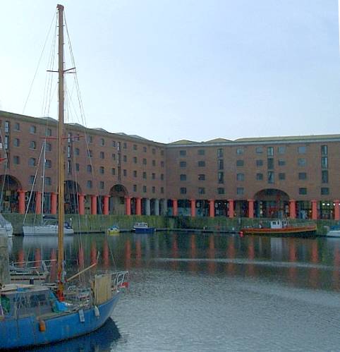
Albert Dock, Liverpool. Jesse Hartley (1780-1860), with Philip Hardwick (1792-1870). 1843-5; opened in 1846
Albert dock was opened, by the late Prince Consort, in 1846; has a water-area of 7 acres 3,542 yards, and a quayage of 585 lineal yards; is appropriated entirely to the rich import trade from India, China, and South America; is surrounded with massive ranges of fire-proof warehouses, which present a fine appearance as seen from the river; and, together with the warehouses and the site, cost £782,265. The warehouses have spacious vaults below quay-level, and five floors above; comprise an area of 138,805 yards; and, besides stowage for wines, spirits, and other goods in the vaults, have stowage, in the upper stories, for 234,950 bales of cotton. A granite islet separates the entrance to the dock into two passages, and is surmounted by a handsome lodge for the lock-keepers; and a spacious promenade extends, parallel with the dock, along the river.

Two more views of the Albert Dock.
Salthouse dock lies landward of Albert dock, and is entered from it; took the name of Salthouse from salt-works originally contiguous to it; was constructed in terms of an act of 1734; was altered and nearly reconstructed in 1844; was enlarged in 1855; has an irregular form, widening over some distance southward from the centre, and then rapidly converging towards the southeast; comprises a water-area of 6 acres 2,019 yards, and a quayage of 784 lineal yards; is appropriated entirely to the export trade, chiefly to India and South America; and is flanked, on the east side, by a very fine granite closed shed, — and, on the north and west sides, by covered sheds.
Duke's dock, immediately south of Albert dock, was constructed by the late Duke of Bridgewater, and used by his trustees and other canal-carriers for their numerous boats; and one end of it runs underneath the centre of a range of large warehouses.

On the Cnal. From a drawing by A. Monroe. English Illustrated Magazine (May 183-1884).
Wapping basin lies immediately south of Salthouse dock, to the east of Duke's dock; was opened in 1855; has a water-area of 1 acre 3,151 yards, and a quayage of 454 lineal yards; is appropriated to an export trade, chiefly in connexion with adjoining docks; and has, along the east side, a fine closed shed for protecrion of goods. The formation of this basin, the enlargement of Salthouse dock, and the formation of Wapping dock, cost about £600,000, and were done for the double purpose of creating increase of dock accommodation, and of constructing an intermediate link for continuous connexion from the extreme northernmost docks southward to Brunswick dock. No such connexion previously existed, so that ships could not pass from north to south or from south to north, except by going out into the river; but now they can go continuously from dock to dock over a distance of about 4 miles.
Wapping dock lies immediately south of Wapping basin, and is entered from it; was opened ia 1855; has a water-area of 5 acres 499 yards, and a quayage of 815 lineal yards; is appropriated to both the import and the export trades, somewhat of a miscellaneous character, but the imports generally of a highly valuable kind; has, along all the east side, a very fine range of fire-proof warehouses, fitted with prime hydraulic machinery for loading and unloading; and has, along the west side, occupying the entire space between it and the east side of King's dock, an excellent shed, 90 feet in span, closed at the ends, and lighted throughout the roof wth thick glass.
King's dock lies between Wapping dock and the river; was opened in 1788; measures 270 yards in length, and 95 yards in breadth; has a water-area of 7 acres 3,896 yards, and a quayage of 875 lineal yards; is appropriated to the tobacco trade, and to the general trade of the port, both foreign and coastwise; and has, along all its west quay, an open shed, and between that and the river, the Queen's tobacco warehouse. This last is a large plain range of brick building, erected by the Liverpool corporation, and rented from them by government; and all the tobacco entering the port is lodged in it, till the qualities are examined and the duties paid. The buildings and machinery for testing chains, ships' cables, and anchors are situated to the north of the tobacco warehouse; and a marine promenade, called the King's parade, extends between the warehouse and the river.
Queen's Half-Tide dock was originally a tidal basin, opened in 1788, and serving as an entrance to King's dock and Queen's dock; was altered into a wet dock and re-opened in 1855; is entered from the river by two passages, divided by a pier, and respectively 70 and 50 feet wide; has a water-area of 3 acres 3,542 yards, aud a quayage of 445 lineal yards; serves as an auxiliary to several adjacent docks; has, on the north quay, a closed shed, — and on the south quay large masting sheers, with a sweep of about 60 feet from the centre, and capable of lifting 20 tons; and communicates, in the upper part of the west side, with two graving docks.
Queen's dock lies landward of Queen's Half-Tide dock and the two connected graving docks, but extends considerably further to the south; is entered either through Queen's Half-Tide dock, or by way of Coburg dock: was formed, to about one-half of its present extent, from the north end. in 1796; was formed, ever the rest of its extent, in 1816: was, at the same time, quayed on both sides, in a manner to suit the then timber trade of the port; was deepened and otherwise improved in 1857; has a water-area of 10 acres 1,564 yards, and a quayage of 1,214 lineal yards; is now appropriated to the general trade of the port and has on the east and the west sides commodious sheds. Some ship-building yards, and a small dock for river craft are situated between Queen's Half-Tide dock and Coburg dock.
Coburg dock and Union dock were originally separate works, formed under an act of 1811; but they were made one work, with the name of Coburg dock, in 1858. The original Coburg dock was a tidal basin; was converted into a wet dock, with entrance-gates 70 feet wide, in 1840; and had a water-area of 4 acres 2, 198 yards. Union dock lay landward of the former; was originally a wet dock; took its name of Union from its serving as a link between Queen's dock and Brunswick dock; aud had a water-area of 2 acres 3,005 yards. The present Coburg dock has a water-area of 8 acres 26 yards, and a quayage of 1,053 lineal yards; is appropriated to the general trade of the port, but is usually occupied on most of the north side by the large Australian steam and sailing packets, and on part of the south side by the steamers trading to Portugal and Spain; and has, on the north side, partially-closed sheds, — on the south side, fine closed sheds, — and on the east side, a very powerful hydraulic crane. — South-Ferry Tidal basin was formed in 1830; has a water-area of 2,927 yards, and a quayage of 205 lineal yards; serves chiefly as a place of shelter for small river-craft; and has, on its quays, the principal establishment of the dock authorities for forming, repairing, aud maintaining the works of the dock-estate.
Brunswick Half-Tide dock was opened in 1832; is entered from the river; has a water-area of 1 acre 3,833 yards, and a quayage of 491 lineal yards; serves as a passage to Bniuswick dock; and has, on its north quay, a sheltering shed. — Brunswick dock extends north and south across the head of Brunswick Half-Tide dock; was opened in 1832; has a water-area of 12 acres 3,010 yards, and a quayage of 1,086 lineal yards; is appropriated, on its east side and part of its west side, entirely to the timber trade; has, on the north quay, an open shed, — and, on about one-half of the west quay, a range of closed sheds for steam and other vessels requiring their use; and communicates, at the south end, with two fine graving docks.
Toxteth dock was originally a tidal basin, called the South basin; was converted into a wet dock, and opened as such in 1842; has a water-area of 1 acre 469 yards, and a quayage of 393 lineal yards; is appropriated to the general trade of the port; and has, in the upper part of the north and south sides, capacious sheds, with lines of railway running into them, for the storage of mahogany aud other foreign wood. — Harrington Tidal basin and Harrington dock were constructed about 1839; passed, by sale, to the general dock estate in 1844; have jointly a water-area of 1 acre 2,817 yards, and a quayage of 623 lineal yards; and are appropriated chiefly to the coasting and the in- land carrying trades.
Herculaneum Half-Tide dock was constructed in 1864-5; is entered from the river by two passages, divided by a pier, and respectively 80 and 60 feet wide; has a water-area of 8 acres 4,809 yards, and a quayage of 540 lineal yards; and communicates, on the S side, through entrances 60 feet In width, with two very fine graving docks, each 750 feet long. — A resolution was taken, about the beginning of Nov. 1866, to construct new works at a cost of about £1,000,000; to include a purchase of 150 acres for a system of new coal-docks, a Herculaneum dock at a cost of $154,000, new corn warehouses at a cost of £155,000, and now carriage-approaches to the river levels at a cost of £170,000. — The total number of graving docks in the harbour is 20, with entrances varying in width from 32 to 100 feet; and they aggregately have a lineal length of 10,125 feet.
Passenger Landing Stages and Docks
Prince's landing-stage, situated opposite the south end of Prince's parade, was opened in 1857; is suited to the embarking and landing of passengers by Channel-goiug steaniers and by sailing-ships, and to the embarking and landing of merchandise in the traffic to and from Birkenhead; is constructed of a number of floating pontoons, bearing a fixed frameivork of timber decked over; measures 1,000 feet in length and 50 feet in width; rises and falls with the tide; and is approached by two iron bridges, one end of which is secured to the pier by a moveable joint or pivot, while the other rests on the stage. Waiting and refreshment-rooms, and offices for the underwriters, steam-ship companies, and customs officers, wth life-boat house, are on the deck; horses and carriages can cross it; and accommodation is afforded by it for several thousands of persons. George's landing- stage, situated opposite the end of the pier-head baths, was opened in 1817; is suited to embarkations and landings in and from the ferry steamers plying between Liverpool and various places on the Mersey; is constructed in the same manner as Prince's landing-stage; measures upwards of 500 feet in length, and 80 feet in width; stands at a distance of 150 feet from the pier; is approached, over that distance, by two swing bridges; has, on deck, refreshment and waiting-rooms, and a projecting shed; and cost, in the construction, about £35,000. — The South landing-stage, situated opposite Harrington dock wall, was opened in 1S65; is suited to the embarking and landing of passengers by the steamers piling to and from New Jersey; consists of a floating stage 120 feet long, and 5O feet wide; and is approached by an iron bridge 150 feet long, and about 60 tons in weight. — A proposal was a-foot, at the beginning of 1866, to construct a new Waterloo pier, to cost about £20,000, and to consist of a platform, 1,500 feet long, carried on 375 iron Columns, in triple tiers, screwed into timber piles, and tied by lattice girders.
The entrance to the harbour is guarded by the North fort on the Liverpool side, and by the New Brighton fort on the Cheshire side. The North fort stands on the shore adjacent to the end of Huskisson dock; is massively constructed of stone; bears, at its entrance, the inscription within a lozenge, V. R. 1854; and, at its sea-ward base, is washed by the tide to a depth of 30 feet. The entrance is on the east side, with, projecting wings and battlemented towers; the doorway is approached over moat and drawbridge, and is arched; the centre of the fort is a square court-yard, on three sides of which are guard-houses, officers' rooms, stables, and other buildings; the bastions are semicircular sweeps of great thickness of wall, flanked by towers for heavy guns; the entrance to each tower is by a strong stone staircase, containing a casemate and artillery store; the aggregate outline of the fort seaward has the form of an arc of a circle; and the interior is always provided with ready-piled shells, and the hot-shot apparatus. The fort, besides affording a striking sight to strangers, in the display of its stores, guns, and other appliances for defence, com- mands a tine and extensive view of the river's scenery. New Brighton fort stands on Porch rock, projecting into the sea; and contains a battery mounting 18 guns, each of 32 pounds.

Links to Related Material
Bibliography
“The Tide of Emigration to the United States and to the Colonies.” Illustrated London News. (6 July 1850): 17.
Wilson, John M. (John Marius). The imperial gazetteer of England and Wales: embracing recent changes in counties, dioceses, parishes, and boroughs: general statistics: postal arrangements: railway systems, &c.; and forming a complete description of the country. 8 vols. Edinburgh: A. Fullarton, 1870.Internet Archive online version of a copy in the Allen County Public Library Genealogy Center. Web. 17 September 2022.
Last modified 19 September 2022