
In transcribing the following paragraphs from the Internet Archive online version of The Imperial Gazetteer’s entry on Hindustan, I have expanded the abbreviations for easier reading and added paragraphing and links. This mid-Victorian reference work has substantial sections on both India and Hindustan, and it is not always clear how Victorians distinguished between the two. The title-page bears the date 1856, but internal evidence in various entrees makes clear that the text dates from 1851 or 1852. This discussion of British India has particular importance because it immediately precedes the 1857 Mutiny.— George P. Landow]
The Mountain Systems of Hindoostan
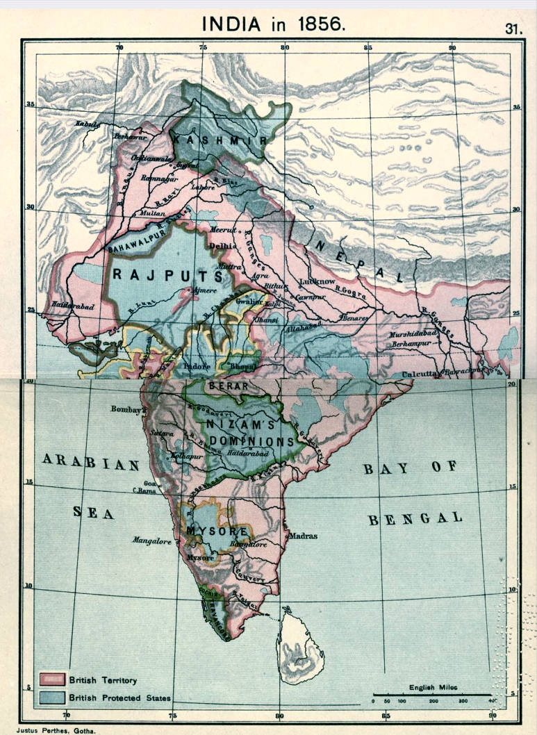
India in 1856. From Joppen’s Historical Atlas of India (1914). Click on image to enlarge it.
The great mountain systems of Hindoostan are the Himalayas, the east and west Ghauts, and the Vindhya range. The Himalayas, forming the north boundary of this region, are one of the loftiest and most stupendous chains of mountains in the world. Their average height is about 15,700 feet; but their loftiest summits, Dhawalagiri and Kunchainjunga, attain an elevation of upwards of 28,000 feet (see HIMALAYA). The east Ghauts commence in the south, about latitude 11˚ 20' north, and, pursuing a northeast direction across the country, extend to the banks of the, Kistnah, in latitude 16˚ north, separating the Carnatic from the table-land of the Deccan. The utmost height of this range does not exceed 3000 feet The west Ghauts extend from Cape Comorin to the river Taptee, about latitude 21˚ north; extending through about 13˚ of latitude, and running parallel to the west coast, from which they are seldom more than 70 miles, and generally only about 40 miles distant. Their highest elevations reach to from 5000 to 6000 feet above sea-level. An offset of this range, however, stretching northeast, was found by Colonel Lambton to have an elevation of 7364 feet This summit, called Mount Permaul, is northwest from Dindigul, in the south Carnatic; and it is believed that there are higher elevations farther west.
The Vindhya Mountains run east and west across the central part of India; constituting a base to the triangle, of which the east and west Ghauts form the other two sides, and complete the boundary of what, is called the table-land of the peninsula. Their greatest height is not supposed to exceed 3000 feet. The surface of the Deccan is between 3000 and 4000 feet above the sea, and is a collection of plains, interspersed with ridges of rock, and insulated flat-topped hills, which are numerous, especially in its northeast parts. These solitary and almost inaccessible heights rise abruptly from the plains, with all but perpendicular sides, which can only be scaled by steps cut in the rock, or by dangerous and winding paths. Many are fortified, and have been strongholds from remote antiquity.
South of the Deccan is the table-land of Mysore, 7000 feet above the sea, surrounded by the Nilgherry or Blue Mountains, and their branches, which rise to 3000 feet higher. The base of this plateau, as of all the Deccan, is granite; there are also many syenitic and trap rocks, with an abundance of primary and secondary fossiliferous strata. The sea-coasts on the two sides of this part of the peninsula are essentially different; that of Malabar, on the west side, is rocky, but in many parts well cultivated; and its mountains, covered with forests, form a continuous wall of very simple structure, 510 miles long, and rather more than 5000 feet high.
On the coast of Coromandel the mountains are bare, lower, frequently interrupted, and the wide maritime plains are, for the most part, parched. The Gangetic plain comprehends the vast tract of level country drained by the Ganges, and its affluents; extending from the Himalaya, on the north, to the Vindhyan, and other ranges, on the south; and on the west to the Indian Desert and the mountains of Kajpootana. The lower portion of this plain (Bengal, &c.) is annually submerged for several months by the inundation of the Ganges. This plain is the most fertile, best cultivated, and most thickly inhabited portion of Hindoostan, containing more than one-half of its entire population.
The Desert of the Indus
The desert of the Indus, or Great Sandy Desert, extends from the southeast confines of the Punjab to the Kunn a distance of about 500 miles; and is connected on the northeast with the high country which separates the plain of the Ganges from that of the Indus. It stretches in a direction parallel to the latter river, but divided from it by a fertile tract of land, from 10 miles to 15 miles in width. It contains several large oases, of which considerable portions are under cultivation. The south part of this desert embraces nearly the whole of the delta of the Indus; across which river it is continuous with the desert of Beloochistan, and with that wide band of sandy and sterile regions stretching from central Africa northeast over the whole centre of the Asiatic continent.
The Rivers of Hindoostan
The rivers of Hindoostan, like its mountains, are on the most magnificent scale. The principal are the Indus, Ganges, and Brahmapootra. The Indus, which forms the western boundary of Hindoostan proper, after having passed the Himalaya, flows in a southwest direction. Its sources lie in Tibet, between latitude 31˚ and 32˚ north Having traversed the Punjab and Scinde, comprising a course of about 1000 miles, it falls, by several mouths, into the Indian Ocean, in about latitude 24˚ north; longitude 68˚ east. Its stream is foul and muddy; and so full of shoals and shifting sands, that it can only be navigated with safety by flat-bottomed boats; with these, it is navigable for about 1200 miles from the sea. It is said to discharge nearly as much water as the Mississippi, and four times more than the Ganges.
The Ganges, though not the largest, is the most important of the Indian rivers, from the fertility it diffuses around it, and the facilities it affords for internal communication. It rises about latitude 31˚ north; longitude 79 east; and after pursuing a southeast course of about 1100 miles, enters, by numerous mouths, into the Bay of Bengal. It is held in high veneration by the Hindoos; who consider its waters so sacred, that to swear upon them constitutes their most binding oath.
The Brahmapootra exceeds the Ganges in size, and probably in the length of its course. Its sources are very imperfectly known; but the main stream is traced to about latitude 28˚ north, and longitude 96˚ east, in Upper Assam, where it is considered to be formed by a junction of the Dihong, Dibong, and Lopit rivers; the second of which penetrates into Assam, from Tibet, breaking into south Asia, like the Indus and Sutlej, by gorges in the Himalaya. The Brahmapootra enters Bengal in the Rungpore district; and, having run a course subsequently of nearly 300 miles in a south and southeast direction, falls into the Bay of Bengal, in about latitude 22˚ 50' north; longitude. 90˚ 45' east; in conjunction with the largest branch of the Ganges. For the last 30 in. of its course it has a breadth of from 4 miles to 5 miles , increased to 10 miles at its mouth..
Amongst the other rivers of note in Hindoostan are the Jumna, Chumbul, Sone, Gunduck, Goggra, Teesta, &c., tributary to the Ganges; the five rivers of the Punjab the Sutlej, Bees, Kavee, Chenab, and Jailum, affluents of the Indus; and in peninsular India the Nerbudda and Taptee, flowing westward; and the Kistnah or Krishna, Godavery, and Mahanuddy, entering the sea on its eastern side.
The Lakes of Hindoostan
In remarkable contrast to its mountains and rivers are the lakes of Hindoostan; the latter being few in number, shallow, and comparatively small in size. Amongst the largest are the Chilka and Colair lakes, both on the eastern shore of the penin sula. The former, a salt water lake, separates the five northern circars, towards the sea, from the district of Cutback. It is about 35 miles in length, and 8 miles in average breadth; its general depth being 4 feet. It abounds in fish, and large quantities of salt are manufactured on its banks. The Colair, a fresh water lake, is situated between the Godavery and the Krishna, about 5 miles east from Elloor. It is of an oval form; and, in the dry season, is about 25 miles in length, and about 10 miles in breadth at its widest part. In the rainy season, it greatly exceeds these limits. It contains numerous islands; which disappear as the lake swells, and re-appear as the floods subside. On a failure of the periodical rains, it dries up altogether.
To make up, however, for the want of natural reservoirs, the whole surface of India is more or less interspersed with tanks, or artificial collections of water, made for the purpose of irrigation; and the construction of which has been always held highly meritorious by the professors of the Brahminical religion. Some of these are of such considerable size as almost to merit the name of lakes; and jeels or large ponds, formed by some of the large rivers during their inundations, are also numerous in several provinces; as in Bengal, and elsewhere.
On the west side of Hindoostan is a remarkable tract of morass, called the Kunn, lying between the province of Cutch and the southeast parts of Scinde, and having communi cation with the Gulf of Cutch. It is about 150 miles in length, and in greatest breadth about 60 miles; its total superficies amounting, at different periods, to between 5000 and 8000 square miles. Several rivers disembogue into this tract, which is diversified with several verdant oases, and on which the phe nomenon of the mirage is of frequent occurrence. The coast line of Hindoostan, having an extent of nearly 3100 miles, is particularly deficient in islands and in inlets; of the latter, two only are of much size the gulfs of Cutch and Cambay, both on the western side. Along all the west coast, Bombay, Cochin, and a few less important localities, are those only which present any good accommodation for shipping; and on the east coast, from Cape Comorin to Bengal, there is not a single good harbour.
The Climate of Hindoostan
From the vast extent of Hindoostan, stretch ing, as it does, through no fewer than 27˚ of latitude, its climate and productions, particularly the former, by position and local influences, can be here spoken of but cursorily; the reader being referred for more minute and ample information on these and other subjects, either not at all, or but slightly, noticed in this article, to the accounts of the various presiden cies, states, provinces, and districts of which the territory is composed, and which will be found under their respective heads.
Generally speaking, Hindoostan has three seasons; the hot, wet, and cold. The first commences about the middle of March, and continues for three months. The heat is, for the most part, intense, and in some places so excessive, especially on the Coromandel coast, as to destroy vegetation; the thermometer ranging, in the sun, from 100˚to 110˚, and rising as high even as 120˚ Fahrenheit. The wet season also occurs during the southwest monsoon, in most parts of India; though, in the country east of the Ghauts, the rains occur when the wind blows from the opposite quarter. The rains are ushered in with a dreadful commotion of the elements lightning, thunder, and tempest; and the rain which it brings, though falling for some time at intervals only, gradually becomes a continuous deluge. These rains, however, though excessive, are highly beneficial; refreshing the earth, invigorating vegetation, and cooling and purifying the atmosphere. The northeast monsoon blows during the winter months, and the southwest during the rest of the year; but both are subject to various modifications, according to local circumstances, particularly the direction of mountain-ranges.
In the cold season, fogs and dews are common; and the degree of cold is so great, in some places, as to render fires necessary. Even in Calcutta, the thermometer falls as low as 52˚ in December, with a northeast wind; and in some of the north provinces to 45˚ and 35. Still, the whole of Hindoostan, except the higher mountain-ranges, may be considered as having a hot climate; for although, north of latitude 27˚, the climate, from November to March, is comparable with that of Italy, the larger part of the territory is within the tropic; and in the low plains, as far north as latitude 18˚, winter is hardly perceptible. At Bombay, the mean annual temperature is stated to be about 82˚; at Madras, 84˚; and at Calcutta, 79˚ Fahrenheit.
Bibliography
Blackie, Walker Graham. The Imperial Gazetteer: A General Dictionary of Geography, Physical, Political, Statistical and Descriptive. 4 vols. London: Blackie & Son, 1856. Internet Archive online version of a copy in the University of California Library. Web. 7 November 2018.
Joppen, Charles. Historical Atlas of India. London: Longsmans, Green, 1914. Internet Archive version of a copy in the University of California Library. Web. 1 October 2014.
Last modified 10 December 2018