
In transcribing the following paragraphs from the Internet Archive online version of The Imperial Gazetteer’s entry on Bombay (modern Mumbai), I have expanded the abbreviations for easier reading and added subtitles, paragraphing, images from elsewhere on the Victorian Web and links. The map is in the original. The title-page bears the date 1856, but internal evidence in various entrees makes clear that the text dates from 1851. This discussion of a major city in British India has particular importance because it immediately precedes the 1857 Mutiny.— George P. Landow]

BOMBAY [Portuguese, Bom-Bahia Good Harbour], a well-known city and seaport, West coast of the peninsula of Hindoostan, capital of the presidency of Bombay, and situated on a narrow point of land at the Southeast extremity of the island of the same name; latitude 18 53 42" North; lomngiotude 72 48 East (n.); 660 miles Northwest Madras, and 1050 miles Southwest Bombay overland, and somewhat more than double that distance by sea. The city is divided into two portions, one lying next to the sea, and surrounded by fortifications; and situate about 1 mile Northwest of the other, called the Black, or Native town. The streets of the former are narrow, without any foot pavement, and in many places choked up with dust. The houses are three, and sometimes four stories high, and are provided with verandahs, which rise one above the other, and are supported by wooden pillars; they have also small bow windows, adorned with neat trellis-work.
In the lower part of the town are the bazaars, which are narrow and dirty, and are chiefly kept by Parsees, an industrious and singularly intelligent race, of Persian descent, to whom a large portion of the mercantile wealth of Bombay belongs, and who assimilate themselves to Europeans in habits, manners, and mode of living, more than any other race in the East. Between the fort and the nearest part of the native town without, is what is called the esplam used as parade and airing ground, on which no permanent building is allowed to be erected.
The European population is accommodated, partly within the fort, in the largest and best-situated houses, but the greater proportion in bungalows, or villas, in various parts of the island; these are generally large and handsome, with extensive areas, called compounds, in front, and built with careful reference to the climate, verandahs encircling the rooms of the house. Bombay Castle, the treasury, the Government-offices, and almost all the merchants warehouses and offices, are situated within the fort.
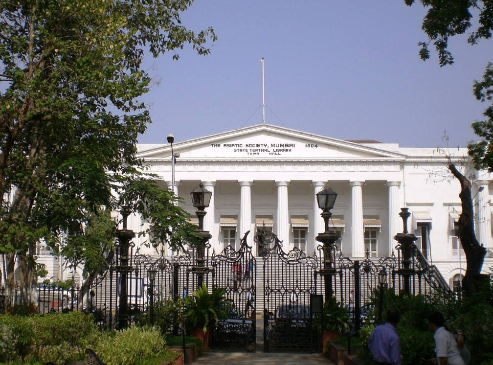
Mumbai’s Neoclassical Town Hall designed by an unknown officer of the Bombay Engineers. 1833. Click on image to enlarge it.
The principal building is the townhouse, within the fort, and occupying the East side of the square called the Bombay Green; it contains many of the Government-offices; a library, rich in collections, gathered from all parts of Asia, and a spacious saloon, adorned with marble statues of Mountstuart Eiphinstone and Sir John Malcolmiles In the centre of the Green itself, is a statue of Lord Wellesley; and another, to the memory of Lord Cornwallis, stands outside the fort, at what is called the church gate.
A great portion of the Black, or Native town, is built on a low tract of land, which, in former times, suffered much from inundations, and was, during seven or eight months in the year, an unwholesome swamp. Much has been done of late to remedy this evil, by draining, and the formation of roads and streets, and with some success, although the streets, which are here also most inconveniently narrow, still continue to abound in nuisances; while, during the rainy season, much sickness and suffering prevail, in consequence of the excessive damp. The houses in Black town are small, built of brick, and two stories in height. The lower stories are kept open as bazaars, in which the dealers sit cross-legged, surrounded by baskets containing piles of merchandise. In the evenings, the scene here is very animated; the streets and bazaars are lighted up with numer ous small lamps, and crowds of natives throng the stalls, examining the goods, and making purchases.
The markets of Bombay, though not equal to those of Calcutta, are well supplied with provisions, mutton, kid, poultry, and fish in abundance, and generally of good quality; the onions are particularly excellent, and as such, are cele brated all over the coast. The wages of servants here are much higher than in Bengal; but food is dearer, which is probably the cause; yet the salaries of the public servants are smaller here than in either of the other two presidencies.
Bombay Harbor
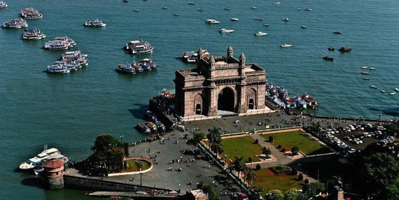
A Monument created three-quarters of a century after Blackie wrote about the city: The Gateway of India designed by George Wittet (1878-1926), Consulting Architect to the Government of Bombay. The foundation stone of this iconic and world-famous structure was laid in 1913, and the work on it was completed in 1927. It was built of yellow basalt and concrete on the Apollo Bunder, Mumbai, and commemorates the visit to India of King George and Queen Mary for the 1911 Delhi Durbar. Click on image to enlarge it.
The harbour of Bombay is one of the largest and safest in India; while its scenery, and that of the neighbouring con tinent, presents a rare combination of grandeur and beauty. It is 12 or 14 miles long, with a general width of from 4 to 6 miles. It is situated between the islands of Colabah, Bombay, and Salsette on the one hand, and the mainland and islands of Caranjah and Elephanta on the other, and is defended by formidable batteries, particularly strong towards the sea. The usual anchorage is on the West side of the harbour, off the town of Bombay. The general depths in approaching the former, are from 14 to 8 fathoms. The docks, which are the property of the East India Company, are under the management of Parsees, by whom the shipbuilding is conducted. Two ships of the line can be completely built and equipped in these docks every 18 months, and the slips and basins are calculated for vessels of any size. The ships constructed here include merchant vessels of large dimensions, occasionally frigates, and even ships of the line; the timber being amply supplied from the neighbouring districts of Malabar and Goojerat.
Bombay’s Population
The population of Bombay has increased tenfold within a century. In 1716, it was estimated at 16,000; in 1816, at 161,550; it is now, according to the census of 1849, upwards of 500,000, composed of British, Portuguese, and Armenians, Jews, Mahometans, Hindoos, and Parsees.
Bombay’s Climate
The mean temperature of Bombay is higher than that of Calcutta, but lower than that of Madras, which is 84 Fahrenheit, Bombay 82, and Bombay 79.
Sources of this entry in The Imperial Gazetteer
Hamilton’s East India Gazetter; Von Orlich’s Travels in India; Porter’s Progress of the Nation; McCulloch’s Account of the British Empire; British Colonial Library; Historical and Descriptive Account of British India; Horsburgh’s East India Directory; The Oriental Interpreter; Private Information, Sic.)
Bibliography
Blackie, Walker Graham. The Imperial Gazetteer: A General Dictionary of Geography, Physical, Political, Statistical and Descriptive. 4 vols. London: Blackie & Son, 1856. Internet Archive online version of a copy in the University of California Library. Web. 7 November 2018.
Last modified 22 November 2018