
In transcribing the following paragraphs from the Internet Archive online version of The Imperial Gazetteer’s entry on Egypt I have divided the long entry into separate documents, expanded abbreviations for easier reading, and added paragraphing and links to material in the Victorian Web. Unless otherwise noted, charts and illustrations come from the original Gazetteer. — George P. Landow
Mountains
The valley of the Nile, throughout its whole extent, from Philae to the vicinity of Cairo, is hemmed in on both sides by continuous chains of hills; those on the East side approach more closely to the river, while the Libyan hills on the West rise with a gradual ascent, and sometimes recede to a distance of 1 or 1½miles. Hence they appear less elevated than the East hills, which vary in height from 400 to 800 feet. Towards the delta these chains of hills diverge; that on the East side turning East by Jebel Mokattem (that is, the hewn; so called probably from its quarries), near Cairo, and sinking gradually till it disappears in the isthmus of Suez; while the Libyan chain skirts to the North of the plains of the Natron lakes.
The desert between the Nile and the Red Sea is intersected by several chains of mountains, which increase in elevation to wards the East, so that the ridges nearest to the Red Sea attain a height perhaps exceeding 6000 feet; West of the Nile, on the other hand, the land evidently sinks, so that the Libyan chain separates the river from a wide valley, which is supposed to be not above the level of the sea, and may probably have received the waters of the Nile, and conducted them to the sea in early times, while the rocky channel through lower Nubia was as yet but imperfectly opened. The appearance and physical character of this region is well described by the name Bahr belamn, or river without water, now estowed on a portion of it.
Valleys and Roads
The openings or lateral valleys of the hills confining the valley of the Nile are comparatively few, or, being little frequented, remain unknown. Those on the East side, with which we are best acquainted, are, the Valley of the Wanderings (of the children of Israel), leading from the neighbourhood of Cairo to the head of the Gulf of Suez, and that through which passes the road from Koptos to Kosseir on the Red Sea. In early ages, when the commerce of the Red Sea was far more important than it is at present, the roads from the Nile through the East desert were numerous and frequented; and there still remains indubitable evidence, chiefly in the ruins of guard-houses and of solidly-constructed wells, of the industry which once animated these inhospitable wastes. West of the Nile, in latitude 29˚ 20' North, a deep sinuosity in the Libyan chain of hills forms the fertile valley of Fayoum (in Coptic, Ph-iom, the sea or lake), in the Northwest and lowest part of which is the lake named Birket-el Kerun, the level of which is perhaps not above that of the river. The East part of the Fayoum was anciently the site of the celebrated Lake Moeris, the embankments enclosing which were first recognized and traced, in 1842, by M. Linant de Bellefonds. From this valley a road leads West, through the hills, to the oasis of Dakhileh. The roads from Jirjeh or Girgeh and Esne to the great oasis are much frequented; and several other openings of less note offer communications with the fertile spots which characterize the depressed region West of the river.
Oases
The oases above alluded to extend, in a narrow line, along the hollow region of the Libyan desert, parallel to the general direction of the valley of the Nile, and above 80 miles West of it The Great Oasis, called, from its chief town, El Wah el Kha-rijeh, lies immediately West of the Thebaid, and has a length of 100 miles, from latitude 24˚ 15' to 25˚ 42' North. About 50 miles West of the North extremity of this oasis, lies the Wah el Dakhileh, 24 miles long and 10 miles broad. In the parallel of Jirjeh and West South from the Fayoum, the date groves of the Little Oasis (Oasis parva), or Wah-el-Baharieh, display their unusual verdure. In this fertile spot artesian wells are numerous, and some of ancient construction have been recently discovered, which have a depth exceeding 400 feet On the road between this oasis and that of El Dakhileh, inclining to the West, occurs half-way the Wah-el-FeraTreh, of small extent. West of Fayoum, and about 200 miles from the Nile, lies the oasis of Siwah, where the foundations of the once-celebrated temple of Jupiter Ammon may still be traced. The inhabitants of this secluded spot, though tributary to Egypt, are in language and manners wholly Libyan. The region of the oases ter minates towards the North in the desert of the Natron lakes, which the Copts called Scete, and where, in the midst of the dreary wilderness, prison-like monasteries offered a congenial home to gloomy and ascetic tempers. The deserts on the West bank of the Nile generally present to view uniform plains of gravel or of fine drifting sand; on the East the scene is varied by rocks and mountains, but the aridity is extreme, and the heat, reverberated from surrounding cliffs, is often insupportable.
Rivers

The Subsiding of the Nile, Egypt. 1873. by Frederick Goodall. Reproduced by kind permission of the Guildhall Gallery, London, and the City of London Corporation.
The only river of Egypt is the Nile, which receives no accession from tributary streams (occasional torrents from extraordinary rains excepted) in the last 1500 miles of its course. At Philrc it enters Egypt with a breadth of 3000 feet, and though often contracted lower down to 2000 feet, its average width throughout may be taken at half a mile, and therefore, with the canals depending on it, bears a considerable proportion to the whole area of the habitable valley. Of the canals alluded to, one of the most remarkable is that commonly called the Bahr Yusef, or Joseph’s river or canal, which, leaving the Nile at Beirut (latitude 26˚ 15'), runs along the foot of the Libyan hills, which it enters at the opening of el-Lahun; and, having watered the valley of Fayoum, it again issues from the Libyan chain and joins the Nile. The Bahr Yusef has a length of 140 miles, and the level plain, often 10 or 12 miles wide, included between it and the Nile, forms, with the valley of Fayoum, the most fertile part of Egypt. Popular belief ascribes the construction of this water-course to Joseph, but competent observers pronounce it to be an ancient branch of the river, flowing between banks for the most part of natural origin. It has a general breadth of 300 feet, and winds like the Nile.
The apex of the Delta was, in the time of Herodotus, at Cercasorus, 10 miles below Memphis; it is now about 6 miles still lower down, at Batn el-Bakara. The river, at the early period referred to, separated at once into three branches, the Canopic going NorthWest, the Pelusiac, Northeast, and the Sebennytic branch proceeding directly North to the sea. But the latter threw off also two other branches, namely, the Saitic, West, and the Mendesian, East Near the former of these flowed the Bolbitine, and, at some distance to the East, the Bucolic branches, both artificial. These were the seven mouths of the Nile as described by Herodotus (from whom later writers differ in many particulars); and it is remarkable that, at the present day, only two of them continue to flow in uninterrupted navigable channels to the sea, and those are the Bolbitine and Bucolic (the artificial) arms, now named respectively, from the towns at their mouths, the Eosetta (Eashid) and Damietta (Dimyet) branches. The artificial branches probably owed their superior permanence to the circumstance of their being cut in a straight line, so that their banks were not liable to be impinged on by the current.
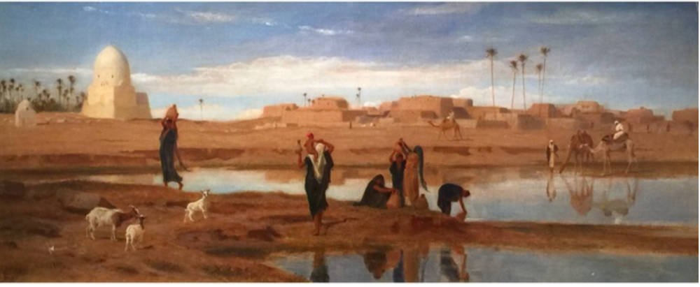
On the Banks of the Nile. 1873. by Frederick Goodall. Reproduced courtesy of the Fine Art Society.
The other ancient arms of the river may still be traced, more or less satisfactorily, among the numerous canals which intersect the Delta, and terminate, for the most part, in the lakes bordering the sea-coast. Among the ancient canals of Lower Egypt, there was one which merits especial notice, namely, that which, starting from the Nile a little below the modern Cairo, ran Northeast and East into the desert, and then turning South, through the marshy district of the Bitter lakes, terminated at Arsinoe, at the head of the Gulf of Suez, thus uniting the Nile and the Red Sea. Pharaoh Necho was the first who ventured on this great undertaking; he failed, however, and Darius, of the Persian dynasty, had no better success. At length Ptolemy Philadelphus overcame the numerous hindrances opposed by nature to the completion of the work; yet, in a few years, this canal, apparently so advantageous, became choked up and useless, and was restored by Trajan, to fall again to ruin. Some traces of it remain at the present day, but for the most part it is wholly obliterated.
One of the greatest works carried on in Egypt in modern times, is that projected by Mahommed Ali for the damming up or barrage of the Nile below Cairo, and for the establishment of canals above the barrage which should carry the water of the stream over the surface of Lower Egypt. The barrage is established at the point of the Delta where the Nile bi-forks into two great branches, which flow, one to Eosetta, the other to Damietta. It is 118 miles from Alexandria, and 99 miles from Eosetta; 12 miles below Cairo, in view of the great pyramids of Gizeh. The works comprehend 1. A sluice bridge on each of the two branches of the river, with a levelling quay, to fix the points of the Delta. 2. Three great canals, one cut on the right bank of the Damietta branch in the direction of Mansqurah, another running along the left branch of the Eosetta branch in the direction of Alexandria, the third placed in the axis of the Delta. The canal directed towards Alexandria is to be 197 feet wide the two others, 328 feet each. The barrage has a length of 1765 feet between the extreme abutments on the Damietta branch, and of 1535 feet on the Eosetta branch, making a length altogether of 3300 feet The quay wall constructed at the point of the Delta is 5291 feet in length. The barrage is expected to be finished in the course of 1852.
Lakes
The first place among the lakes of Egypt has been hitherto usually assigned to the Birket-el-Kerun, lying NorthWest of el-Fayouin, owing probably to the celebrity which attached to it from the supposition that it was a remnant of the ancient lake Moeris. It has a length of about 34 m., and a general breadth of 6 miles; its direction being from West by South to East by North On its shores stands a castle, the projecting spouts of which have procured for it the appellation of Kasr-el-Kerun, (Horn Castle), whence the lake takes it name. It abounds with fish, and like Lake Moeris of old, is farmed out to fisher men, to the great profit of the Government. There can be no doubt that this lake is of natural origin, but it probably owes a great increase of size to the causes which led to the disap pearance of Lake Moeris. So long as the great reservoir, on the higher level of the valley, was maintained in good con dition, its embankments must have cut off supplies from the natural hike below. At present the Nile, in cases of high flood, makes its way to the Birket-el-Kerun, which then rises 4 or 5 feet
About 50 miles North of the Birket-el-Kerun, where the Libyan chain of hills, West of the Nile, begins to sink in the desert, a low tract, extending SouthEast to NorthWest, exhibits in the rainy season a chain of pools, known as the Natron Lakes; from which, in the dry season, the water evaporates, leaving the ground thickly encrusted with natron (sesquicarbonate of soda) , better known in commerce under the name of trona. The fertile land of the Delta is, for the most part, separated from the sea by a series of lakes, or rather vast lagoons, which are themselves fenced from the sea by very narrow necks of land. On the West side of the Delta, and proceeding West to East, these maritime lakes are, Mareotis, Madyeh or Abukir, and Edku or Etko. They all communicate with the sea by shallow openings. Between the Eosetta and Damietta arms of the Nile, Lake Bourlos occupies half of the coast, or above 30 miles; while East of the latter arm, Lake Menzaleh covers an extent of 500 sq. miles; while Lake Bardowal (Sirbonis) stretches 70 miles still further East Altogether, the frontier covered by these lagoons has an extent little short of 200 miles They all abound in fish, but more particularly Lake Menzaleh, the shores of which are rendered hateful to strangers by the smell of fish and mud, by filth and pestilence. From the Souteast angle of Lake Menzaleh, a low tract, annually converted into a swamp during the inundation, winds South by East across the desert isthmus to Suez; in the South part of this tract are the Bitter Lakes, which are very like the Natron Lakes of the West. [2.908]
Bibliography
Blackie, Walker Graham. The Imperial Gazetteer: A General Dictionary of Geography, Physical, Political, Statistical and Descriptive. 4 vols. London: Blackie & Son, 1856. Internet Archive. Inline version of a copy in the University of California Library. Web. 31 July 2020.
Last modified 1 August 2020