
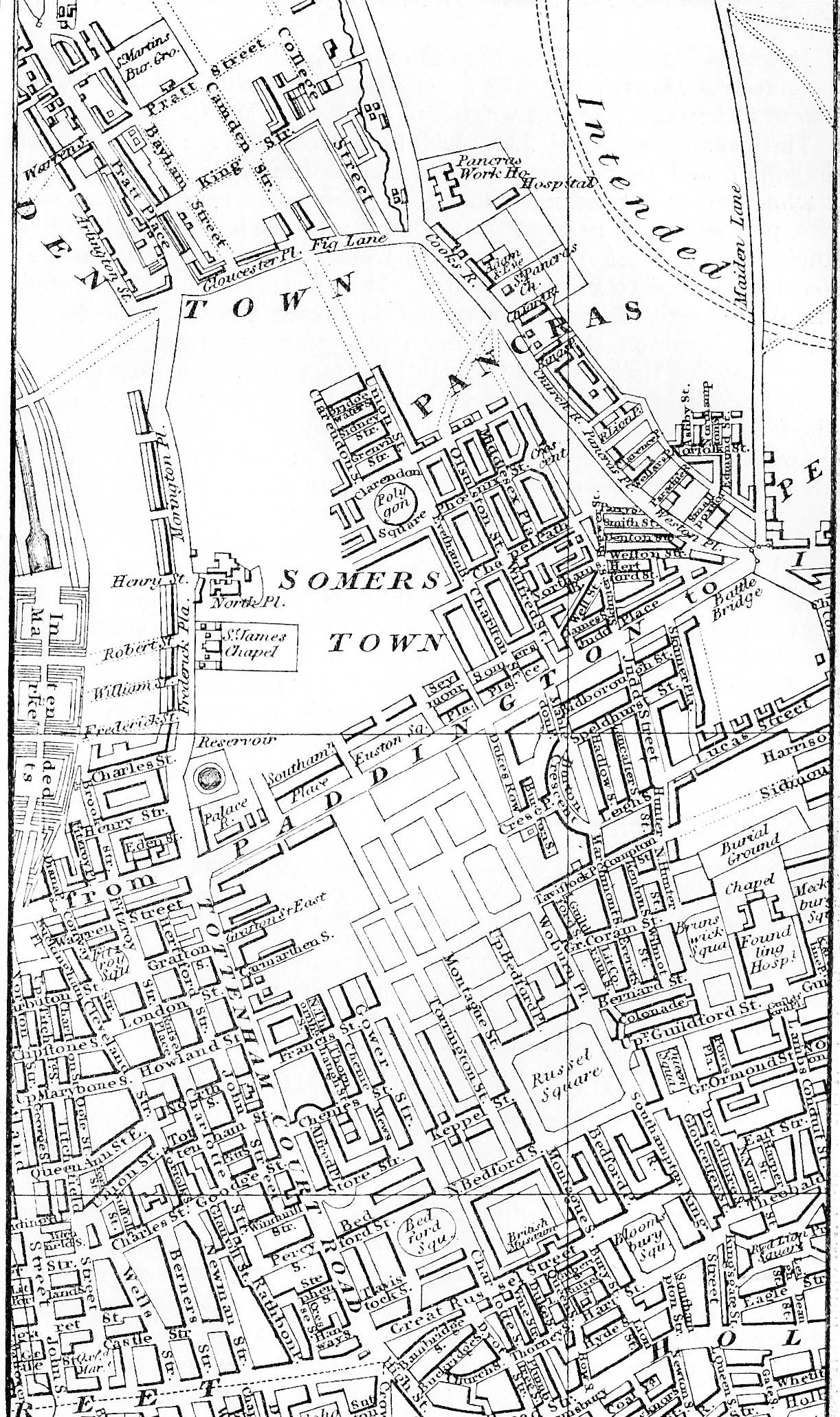

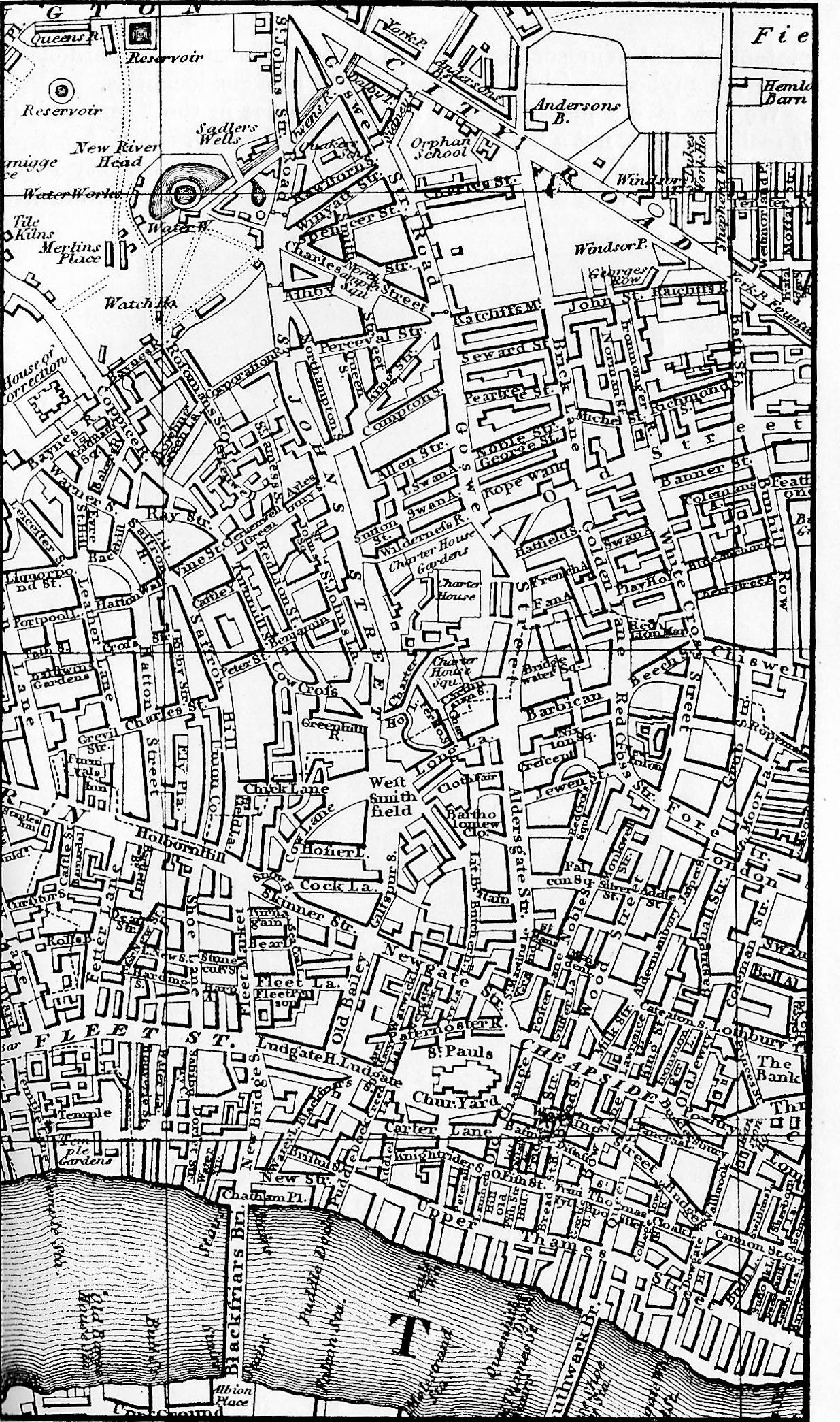
Left: Map London in 1818. Middle: Map London in 1850. Right: Map Central London in 1850. [Click on maps to enlarge them.]
In 1929 when the Dickensian ran these maps to demonstrate the changes wrought by a century of population growth, urban sprawl, and technological expansion, the lineaments of Dickens's London were still discernible — just six decades having passed since his death. Even his former residence on Doughty Street looked much the same in 1929 as it had when Dickens wrote The Pickwick Papers, Oliver Twist, and Nicholas Nickleby there from 1837 through 1839. Walter Dexter associates the London of the Regency with A Christmas Carol, for the novella recalls the days when the Dickenses lived at 18 Bayham Street in Camden Town, before the Great West Railway sliced through Wellington House Academy, Dickens's old school, at the corner of Grandby Street. The association of the London of 1850 with David Copperfield is perhaps more obvious, for that was when the novel was appearing in monthly instalments, although the opening chapters recall the England of two to three decades earlier. The earlier of the two maps was already five years old when Charles Dickens arrived by coach from Chatham, Kent. The railway had not yet arrived in London, and such famous streets as Euston and Hampstead Roads did not yet exist.
Johnson Street, where the Dickens family lived in 1825, is not shown [in the 1818 map]; it was probably not built at the time; but the Polygon where they also once lodged for a time (1827-8), and where Dickens housed Harold Skimpole in the novel Bleakhouse years later, is seen in the centre of Claredon Square. . . . . A further examination of the map will show the way Dickens used to walk to the blacking warehouse at Hungerford Stairs from his lodgings in Camden Town [when his father was incarcerated in the Marshalsea for debt] — at Mrs. Roylance's, in Little College Street (now College Place) the turning out of Fig Lane (now Crowndale Road) next Great College Street. ["London as Dickens First Knew It," 59]
However, much of what is recognizable in the fiction of Dickens is evident on the 1818 map, including the Foundling Hospital (just below centre, right), Bloomsbury Square (lower right), and Montague Place; and modern streets follow the contours of the map and often bear the same names, as, for example Great Russell Street (bottom centre). The 1850 map, corresponding to the area covered by the 1818 map, shows tremendous growth in the upper quadrant, including railways and Regent's Canal.
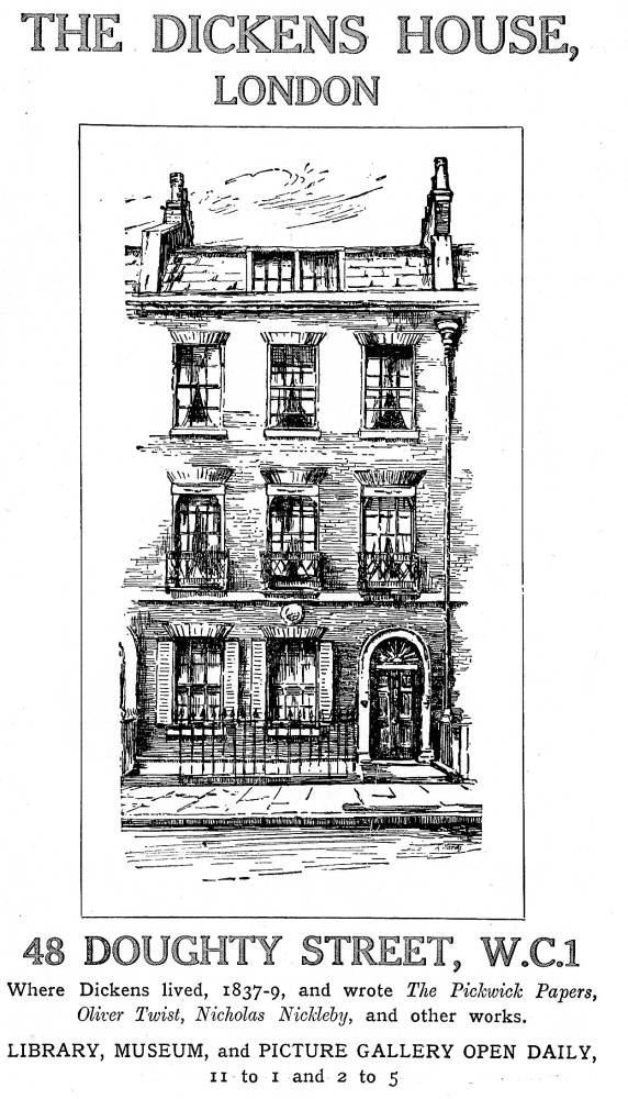

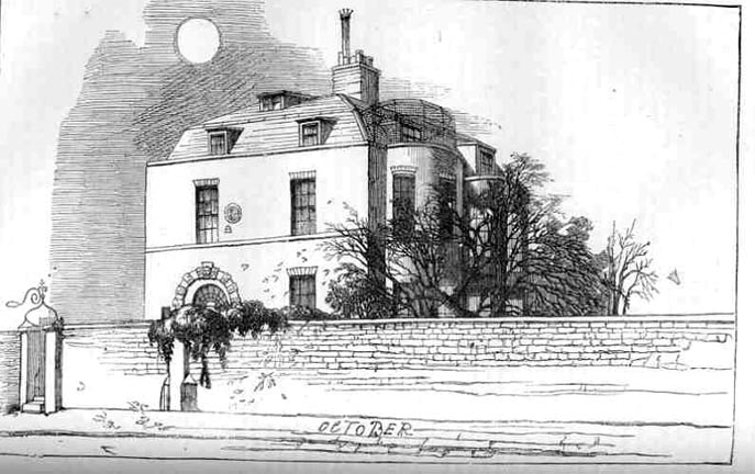
Left to right: (a) Advertisement for the Dickens House Museum, London (b) The Doughty Street House. (c) Devonshire Terrace. [Click on these images for larger pictures.]
Neither the 1818 nor the 1850 map shows No. 48, Doughty Street, Bloomsbury, a Georgian house into which Dickens and his wife moved on 25 March 1837. Here on 7 May 1837, following an outing to the St. James's Theatre to watch the performance of Dickens's own farce Is She His Wife?, his beloved seventeen-year-old sister-in-law, Mary Hogarth, collapsed and died in his arms. The growing Dickens family lived here until December 1839, when they took up residence at No. 1, Devonshire Terrace. In 1902 the newly-formed Dickens Fellowship acquired No. 48 Doughty Street as its headquarters. Threatened with demolition in 1923, in 1925 under a separate trust it became the Dickens House Museum, as advertised in the 1929 issues of the Dickensian.
Left to right: (a) Advertisement for the Dickens House Museum, London. (b) . [Click on these images for larger pictures.]
The third map, Central London in 1850, covers the area of City Road, Islington (top) down to the Thames bridges at Blackfriars and Southwark (bottom), with Fleet Street and St. Paul's Cathedral appearing prominently in the bottom register.


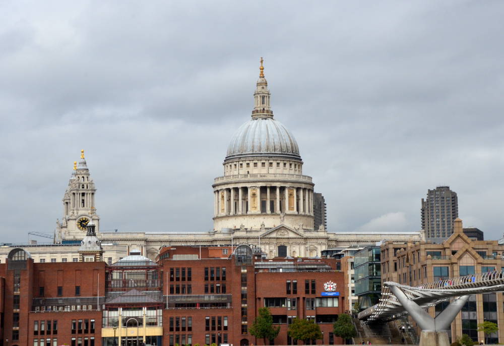
Left to right: (a) Blackfriars Bridge. (b) Southwark Bridge. (c) St. Paul's Cathedral [Click on these images for larger pictures.]
The area is rife with Dickensian associations, so that a few examples must suffice. Windsor Terrace, City Road (top) was Mr. Micawber's residence in David Copperfield. Barbican (right of centre) is where the Prentice Knights assembled in Barnaby Rudge. Batholomew Close and Little Britain both appear in Great Expectations, and Goswell Street was the area where Mr. Pickwick, to his great misfortune, took rooms with Mrs. Bardell. Just off the map, down river, is the naval district of Limehouse where Charles Dickens's godfather, Christopher Huffam worked as a ships' rigger. Although the district appears briefly in Dombey and Son as the home of Captain cuttle (No. 9, Brig Place), it occurs more prominently as the home of the Hexam family in Our Mutual Friend.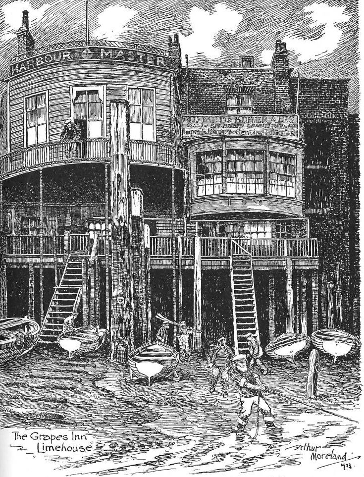
The Grapes Inn, Limehouse by Arthur Moreland
In the area of Limehouse, too, is the fictional Six Jolly Fellowship Porters; its original is given in a wood-engraving from drawing "The Grapes Inn, Limehouse" by Arthur Moreland, 1928 (p. 113) from the same artist's Dickens in London, published by Cecil Palmer in December 1927:
The accompanying illustration of the Grapes Inn at Limehouse, is said to be the original of the Six Jolly Fellowship Porters [in Our Mutual Friend . . . the artistic whole of the scene appealed to Mr. Moreland, rather more than the little Inn itself; otherwise he would not have allowed the beautiful bow window of the Grapes to have been so completely overshadowed by the fine architecture of the harbour master's office. [W. D., "Pictures of London," 114]
"W. D."is likely early twentieth-century Dickensian enthusiast Walter Dexter. Arthur Moreland (1867-1951) was a commercial artist noted for his humorous caricatures and his knowledge of Dickens's works. Born in Lancashire, he moved to London in his twenties, working as a freelance newspaper and book illustrator, by the outbreak of WWI he had established himself as a political cartoonist favouring the Liberals in the 1906 general election. After the war, he became a sports illustrator in The Comic History of Sport (London, T. Werner Laurie, 1924). In his retirement, he produced Dickens in London (London: Cecil Palmer, 1928) and Dickens Landmarks in London (London: Cassell, 1931); the present illustration is excerpted from the former book.
The early numbers of the Dickens Fellowship journal, the Dickensian, are full of black-and-white photographs of sites in England and abroad associated with Dickens's life and works. In the three issues for 1929, for example, are small-scale photographs of The Red Lion, Barnet; The Eight Bells, Hatfield; Rockingham Castle; The George at Grantham; the Carlton Hotel, New York City; the Park Theatre, New York City; Washington Irving's House, New York City; the original of Dotheboys Hall, Yorkshire; a boat-house on the Gravesend-Higham Canal thought to be the original of the Peggotty boat-house; Wemmick's castle; Jasper's gatehouse and the Chalet, Rochester; and the Micawber house on Windsor Terrace, City Road, London — many of these taken by Walter Dexter.
Related Material
- Dickens's homes and other places associated with him
- A Brief History of London
- London buildings (sitemap)
- The River Thames in the Visual Arts
- The Transformative Power of Victorian Railways
- Dickens's attitude towards the Age of Steam
References
Dexter, Walter. "London as Dickens First Knew It." Dickensian 25 (1929): 58-59.
Dexter, Walter. "The London Dickens Knew. II." Dickensian 25 (1929): 104-105.
Dexter, Walter. "The London Dickens Knew. IV." Dickensian 25 (1929): 272-273.
Dexter, Walter. "Pictures of London." [includes reproduction of Moreland's "The Grapes Inn, Limehouse"] Dickensian 25 (1929): 112-114.
"The Dickens House, London." [advertisement] Dickensian 25 (1929): 242.
Lynch, Tony. Dickens's England, A Traveller's Companion: An A-Z Tour of the Real and Imagined Locations. London: Batsford, 2012.
Last modified 24 June 2013